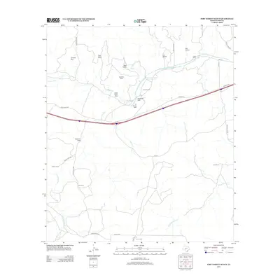
2012 Map of Fort Terrett Ranch
USGS Topo · Published 2012About this map
Fort Terrett Ranch serves as the focal point of this Central Texas landscape, where the N Llano River and its various draws and hollows shape the terrain. The area is defined by its ranching history, with established properties such as Anderson Ranch, Foster Ranch, and Burton Ranch scattered across the Sutton County countryside. Natural landmarks like Chimney Bluff, Twin Buttes, and Ft Terrett Peak provide prominent navigation points above the river valley. The river system includes notable local water features like Fort Terrett Spring and the Kingfisher Waterhole, which historically provided essential water sources in this semi-arid region. Connectivity is maintained through a network of local roads and draws, including Eightmile Draw and North Llano Draw, which direct drainage toward the Dry Llano River at the western edge of the survey.
Find a feature on this map
37 named features on this map. Tap any name to fly to it.
Don’t see what you’re looking for? This feature index may not catch every label — zoom into the map to look around manually.
Map Details
Editions of this 2012 Fort Terrett Ranch Map
This is the sole edition of this map. No revisions or reprints were ever made.
Other maps of this area

1893 · Rock Springs
USGS Topo · 1:125,000

1893 · Fort McKavett
USGS Topo · 1:125,000

1954 · Sonora
USGS Topo · 1:250,000

1958 · Sonora
USGS Topo · 1:250,000

1962 · Hill Ranch
USGS Topo · 1:24,000

1962 · Roosevelt
USGS Topo · 1:24,000

1962 · Stewart Ranch
USGS Topo · 1:24,000
1962 · Bundy Ranch
USGS Topo · 1:24,000

1963 · Live Oak Draw
USGS Topo · 1:24,000

1963 · McKegan Draw
USGS Topo · 1:24,000