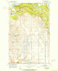
1951 Map of Fort Totten
USGS Topo · Published 1953About this map
Fort Totten and the Fort Totten Indian Agency serve as the focal point for this early 1950s survey of the southern shoreline of Devils Lake. The landscape is defined by the glacial geography of the Spirit Lake Reservation, featuring the prominent heights of Sullys Hill and the Sullys Hill National Game Preserve. The map documents a complex hydraulic environment where the Big Coulee drains south toward Wood Lake, cutting through a terrain dotted with small glacial lakes such as Sweetwater Lake and Mallard Lake. Evidence of early 20th-century rural infrastructure is visible in the presence of the Great Northern railroad line in the northeast and isolated educational landmarks like the Lone Tree Sch No 1 and the already Pleasant Prairie Sch No 1 (Abandoned), which suggest shifting settlement patterns on the prairie during this post-war era.
Find a feature on this map
24 named features on this map. Tap any name to fly to it.
Don’t see what you’re looking for? This feature index may not catch every label — zoom into the map to look around manually.
Map Details
Editions of this 1951 Fort Totten Map
2 editions found
Other maps of this area

1928 · Tokio
USGS Topo · 1:62,500

1931 · Oberon
USGS Topo · 1:62,500

1931 · Tokio
USGS Topo · 1:62,500

1931 · Devils Lake
USGS Topo · 1:62,500

1932 · Grahams Island
USGS Topo · 1:62,500

1950 · Sheyenne
USGS Topo · 1:24,000
1950 · Tokio SW
USGS Topo · 1:24,000

1950 · Tokio
USGS Topo · 1:24,000

1950 · Grahams Island
USGS Topo · 1:62,500

1950 · Devils Lake
USGS Topo · 1:62,500
Featured Places
- Wood Lake District, ND
- St. Michael District, ND
- Fort Totten District, ND
- Fort Totten, Fort Totten District
- Ramsey County, ND