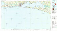
1978 Map of Fort Walton Beach
USGS Topo · Published 1980About this map
Eglin Air Force Base dominates the northern landscape of this 1970s survey, a period when the military presence and coastal tourism began to shape the modern identity of the Florida Panhandle. The map captures the intricate shoreline of Choctawhatchee Bay and the Santa Rosa Sound, highlighting the critical passage of the Intracoastal Waterway. Along the Gulf, the Santa Rosa Island beach ridge is shown with its shifting sand dunes, stretching past developing communities like Destin, Miramar Beach, and Grayton Beach.
Find a feature on this map
81 named features on this map. Tap any name to fly to it.
Don’t see what you’re looking for? This feature index may not catch every label — zoom into the map to look around manually.
Map Details
Editions of this 1978 Fort Walton Beach Map
2 editions found
Other maps of this area

1920 · Milton
USGS Topo · 1:62,500

1921 · Holley
USGS Topo · 1:62,500

1921 · Pensacola
USGS Topo · 1:62,500

1934 · Holt
USGS Topo · 1:48,000

1934 · Harold
USGS Topo · 1:62,500

1934 · Niceville
USGS Topo · 1:48,000

1935 · Villa Tasso
USGS Topo · 1:48,000

1935 · De Funiak Springs
USGS Topo · 1:48,000

1936 · Niceville
USGS Topo · 1:62,500

1936 · Point Washington
USGS Topo · 1:48,000