
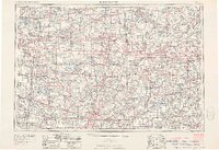
1953 Map of Fort Wayne
USGS Topo · Published 1963About this map
The industrial and agricultural heart of the Tri-State region converges at Fort Wayne, where the St Marys River and St Joseph River meet to form the Maumee River. This mid-century survey illustrates a landscape defined by its heavy rail infrastructure and a dense network of post-war highways. The New York Central and Pennsylvania railroads bisect the terrain, connecting manufacturing hubs like Elkhart and Goshen to the broader eastern United States.
Find a feature on this map
250 named features on this map. Tap any name to fly to it.
Don’t see what you’re looking for? This feature index may not catch every label — zoom into the map to look around manually.
Map Details
Editions of this 1953 Fort Wayne Map
4 editions found
Other maps of this area

1904 · Ann Arbor
USGS Topo · 1:125,000

1906 · Saline
USGS Topo · 1:62,500

1906 · Columbus Grove
USGS Topo · 1:62,500

1907 · Bluffton
USGS Topo · 1:62,500
1907 · Defiance
USGS Topo · 1:62,500

1908 · Ann Arbor
USGS Topo · 1:125,000

1908 · Columbus Grove
USGS Topo · 1:62,500
1908 · Ottawa
USGS Topo · 1:62,500
1908 · Napoleon
USGS Topo · 1:62,500
1909 · Mc Clure
USGS Topo · 1:62,500