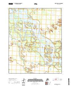
2018 Map of Fort Yukon A-1 SW
USGS Topo · Published 2018About this map
The Yukon River dominates this landscape, its braided channels and seasonal sandbars shifting across the interior of the Yukon-Koyukuk region. In this 2018 survey, the river is shown in a state of constant transition, with intricate waterways like the Twentytwo Mile Slough carving through the low-lying wetlands. The absence of roads or permanent settlements underscores the isolation of this subarctic environment, where the river serves as the primary corridor for movement. Natural landmarks like the Okalee Spit demonstrate the accumulation of river sediment, creating distinct landforms within the vast river basin. This map documents the precise boundaries of several townships, including t15n r15e, t15n r16e, t14n r15e, and t14n r16e, providing a technical look at how this unorganized territory is structured for public land management.
Find a feature on this map
7 named features on this map. Tap any name to fly to it.
Don’t see what you’re looking for? This feature index may not catch every label — zoom into the map to look around manually.
Map Details
Editions of this 2018 Fort Yukon A-1 SW Map
This is the sole edition of this map. No revisions or reprints were ever made.
Other maps of this area

1951 · Fort Yukon
USGS Topo · 1:250,000

1951 · Circle
USGS Topo · 1:250,000

1952 · Circle D-2
USGS Topo · 1:63,360

1955 · Circle D-1
USGS Topo · 1:63,360

1955 · Circle
USGS Topo · 1:250,000

1956 · Fort Yukon A-2
USGS Topo · 1:63,360

1956 · Fort Yukon A-1
USGS Topo · 1:63,360

1956 · Fort Yukon
USGS Topo · 1:250,000

1964 · Circle
USGS Topo · 1:250,000
1966 · Fort Yukon A-2
USGS Topo · 1:63,360