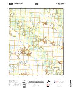
2018 Map of Fort Yukon A-2 SE
USGS Topo · Published 2018About this map
Birch Creek winds through an intricate network of wetlands and meander scars in this 2018 survey of the Yukon-Koyukuk region. The landscape is defined by the shifting hydrology of the northern interior, where complex drainage patterns are evident in the winding courses of Little Preacher Creek and the scattered waters of the Geese Lakes. The sheer density of seasonal water bodies and oxbow formations surrounding Crosstrail Lake illustrates a wilderness largely untouched by permanent road infrastructure or industrial development. This survey serves as a vital record of the shifting hydrological boundaries within the T14N and T15N townships, providing an exact account of the terrain before further environmental change.
Find a feature on this map
9 named features on this map. Tap any name to fly to it.
Don’t see what you’re looking for? This feature index may not catch every label — zoom into the map to look around manually.
Map Details
Editions of this 2018 Fort Yukon A-2 SE Map
This is the sole edition of this map. No revisions or reprints were ever made.
Other maps of this area

1951 · Fort Yukon
USGS Topo · 1:250,000

1951 · Circle
USGS Topo · 1:250,000

1952 · Circle D-2
USGS Topo · 1:63,360

1955 · Circle D-1
USGS Topo · 1:63,360

1955 · Circle
USGS Topo · 1:250,000

1956 · Fort Yukon A-2
USGS Topo · 1:63,360

1956 · Fort Yukon A-1
USGS Topo · 1:63,360

1956 · Fort Yukon
USGS Topo · 1:250,000

1964 · Circle
USGS Topo · 1:250,000
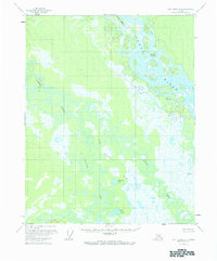
1966 · Fort Yukon A-2
USGS Topo · 1:63,360