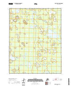
2018 Map of Fort Yukon B-4 NE
USGS Topo · Published 2018About this map
Yukon Flats defines this vast alluvial landscape, where the shifting hydrology of the interior creates a dense network of seasonal wetlands and permanent water bodies. Large, named features like Twelvemile Lake and Chissovun Lake occupy the central and eastern portions of the quadrangle, while Tlozhavun Lake is situated to the west. This 2018 survey illustrates a complex riparian environment where the Upper Mouth Birch Creek meanders through the southern reaches. The absence of roads or permanent settlements in this region emphasizes the dominance of natural water systems, illustrating the remote character of the Yukon-Koyukuk Census Area. This map is essential for understanding the contemporary geography of the flats, showing the exact positions of these significant lakes and the intricate drainages that connect them across the township lines.
Find a feature on this map
9 named features on this map. Tap any name to fly to it.
Don’t see what you’re looking for? This feature index may not catch every label — zoom into the map to look around manually.
Map Details
Editions of this 2018 Fort Yukon B-4 NE Map
This is the sole edition of this map. No revisions or reprints were ever made.
Other maps of this area

1951 · Fort Yukon
USGS Topo · 1:250,000

1952 · Fort Yukon C-3
USGS Topo · 1:63,360

1952 · Fort Yukon C-4
USGS Topo · 1:63,360

1955 · Fort Yukon C-3
USGS Topo · 1:63,360

1956 · Fort Yukon B-4
USGS Topo · 1:63,360

1956 · Fort Yukon B-3
USGS Topo · 1:63,360

1956 · Fort Yukon
USGS Topo · 1:250,000
1956 · Fort Yukon C-4
USGS Topo · 1:63,360
2018 · Fort Yukon B-4 SW
USGS Topo · 1:25,000
2018 · Fort Yukon B-4 SE
USGS Topo · 1:25,000