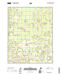
2018 Map of Fort Yukon B-4 NW
USGS Topo · Published 2018About this map
Yukon Flats characterizes the landscape of this 2018 survey, where the intricate hydrology of the interior reveals a complex network of wetlands and shifting watercourses. The most prominent feature is the winding path of Upper Mouth Birch Creek, which meanders through the southern half of the quadrangle, leaving behind numerous oxbow lakes and sloughs. This terrain is representative of the vast alluvial plains north of the Yukon River, where the slow-moving water of Tajittro Creek creates a labyrinthine drainage pattern. The map provides a precise layout of the Public Land Survey System grid across portions of t18n r8e, t18n r9e, t19n r8e, and t19n r9e, offering a detailed view of these remote township boundaries within the census area.
Find a feature on this map
8 named features on this map. Tap any name to fly to it.
Don’t see what you’re looking for? This feature index may not catch every label — zoom into the map to look around manually.
Map Details
Editions of this 2018 Fort Yukon B-4 NW Map
This is the sole edition of this map. No revisions or reprints were ever made.
Other maps of this area

1951 · Fort Yukon
USGS Topo · 1:250,000

1952 · Fort Yukon C-4
USGS Topo · 1:63,360

1955 · Fort Yukon C-5
USGS Topo · 1:63,360

1956 · Fort Yukon B-4
USGS Topo · 1:63,360

1956 · Fort Yukon C-5
USGS Topo · 1:63,360

1956 · Fort Yukon B-5
USGS Topo · 1:63,360

1956 · Fort Yukon
USGS Topo · 1:250,000
1956 · Fort Yukon C-4
USGS Topo · 1:63,360
2018 · Fort Yukon B-4 SW
USGS Topo · 1:25,000
2018 · Fort Yukon B-4 SE
USGS Topo · 1:25,000