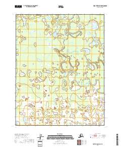
2018 Map of Fort Yukon B-5 NE
USGS Topo · Published 2018About this map
Yukon Flats dominates this portion of the interior, revealing a complex landscape of shifting waterways and wetlands characteristic of the northern wilderness. The hydrological network is anchored by Upper Mouth Birch Creek, which meanders through the terrain alongside Tajittro Creek. The lack of road infrastructure or permanent settlements underscores the isolation of this region within the Yukon-Koyukuk Census Area during the early twenty-first century.
Find a feature on this map
7 named features on this map. Tap any name to fly to it.
Don’t see what you’re looking for? This feature index may not catch every label — zoom into the map to look around manually.
Map Details
Editions of this 2018 Fort Yukon B-5 NE Map
This is the sole edition of this map. No revisions or reprints were ever made.
Other maps of this area

1951 · Fort Yukon
USGS Topo · 1:250,000

1952 · Fort Yukon C-4
USGS Topo · 1:63,360

1955 · Fort Yukon C-5
USGS Topo · 1:63,360

1956 · Fort Yukon B-4
USGS Topo · 1:63,360

1956 · Fort Yukon C-5
USGS Topo · 1:63,360

1956 · Fort Yukon B-5
USGS Topo · 1:63,360

1956 · Fort Yukon
USGS Topo · 1:250,000
1956 · Fort Yukon C-4
USGS Topo · 1:63,360
2018 · Fort Yukon B-4 SW
USGS Topo · 1:25,000
2018 · Fort Yukon C-5 SW
USGS Topo · 1:25,000