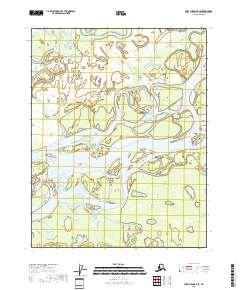
2018 Map of Fort Yukon C-5 SE
USGS Topo · Published 2018About this map
Yukon River dominates this interior landscape, weaving a complex network of braided channels and shifting islands across the center of the sheet. The hydrological character of the region is defined by the slow-moving waters of Crazy Slough to the north and the winding path of the Feedziinjik River as it approaches the main river system from the northeast. In the southern portion of the survey, the Upper Mouth Birch Creek flows through a dense mosaic of wetlands, illustrating the seasonally dynamic nature of the subarctic floodplains. This 2018 data from the U.S. Geological Survey provides a precise record of these watercourses before natural erosion or siltation further alters their intricate paths.
Find a feature on this map
10 named features on this map. Tap any name to fly to it.
Don’t see what you’re looking for? This feature index may not catch every label — zoom into the map to look around manually.
Map Details
Editions of this 2018 Fort Yukon C-5 SE Map
This is the sole edition of this map. No revisions or reprints were ever made.
Other maps of this area

1951 · Fort Yukon
USGS Topo · 1:250,000

1952 · Fort Yukon C-4
USGS Topo · 1:63,360

1955 · Fort Yukon C-5
USGS Topo · 1:63,360

1956 · Fort Yukon B-4
USGS Topo · 1:63,360

1956 · Fort Yukon C-5
USGS Topo · 1:63,360

1956 · Fort Yukon B-5
USGS Topo · 1:63,360

1956 · Fort Yukon
USGS Topo · 1:250,000
1956 · Fort Yukon C-4
USGS Topo · 1:63,360
2018 · Fort Yukon C-5 SW
USGS Topo · 1:25,000
2018 · Fort Yukon C-4 NW
USGS Topo · 1:25,000