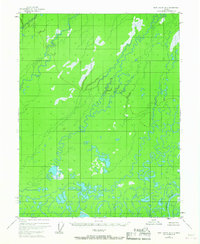
1955 Map of Fort Yukon D-2
USGS Topo · Published 1967About this map
The Sheenjek River winds through this expanse of the Yukon-Koyukuk region, defining a landscape dominated by intricate hydrological patterns. Surveyed from 1955 aerial photography, the terrain is characterized by a dense network of meanders, oxbow lakes, and wetland areas that illustrate the shifting nature of the river system. Because no roads or trails are noted on the sheet, the map provides a pure record of the natural drainage and unsurveyed land lines as predetermined by the Bureau of Land Management. The heavy concentration of swamp symbols and low-relief contours indicates a seasonally dynamic environment where water is the primary architect of the landscape. Researchers can use this record to study the historical course of the Sheenjek River before subsequent decades of natural erosion and channel migration altered the basin.
Find a feature on this map
1 named feature on this map. Tap any name to fly to it.
Don’t see what you’re looking for? This feature index may not catch every label — zoom into the map to look around manually.
Map Details
Editions of this 1955 Fort Yukon D-2 Map
2 editions found
Other maps of this area

1951 · Fort Yukon
USGS Topo · 1:250,000

1951 · Christian
USGS Topo · 1:250,000

1952 · Fort Yukon C-2
USGS Topo · 1:63,360

1952 · Fort Yukon C-3
USGS Topo · 1:63,360

1955 · Fort Yukon D-2
USGS Topo · 1:63,360

1955 · Fort Yukon D-3
USGS Topo · 1:63,360

1955 · Fort Yukon C-3
USGS Topo · 1:63,360

1956 · Fort Yukon C-1
USGS Topo · 1:63,360
1956 · Fort Yukon D-1
USGS Topo · 1:63,360

1956 · Christian
USGS Topo · 1:250,000