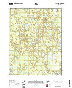
2018 Map of Fort Yukon D-4 SW
USGS Topo · Published 2018About this map
Yukon Flats defines the landscape of this Interior Alaska region, characterized by an intricate network of wetlands, ponds, and meandering waterways. The Tredriinjik River enters the frame from the southwest, while Kocacho Cr and Marten Cr thread through the complex marshlands that dominate the central and eastern sections. This survey documents the natural hydrography of the subarctic basin, where the absence of roads or permanent settlements emphasizes the role of these watercourses as the primary geographic markers. The terrain is structured by the Public Land Survey System, spanning townships from t24n r8e to t22n r9e, providing a precise grid for navigating one of the state's most water-rich and undeveloped wilderness corridors.
Find a feature on this map
10 named features on this map. Tap any name to fly to it.
Don’t see what you’re looking for? This feature index may not catch every label — zoom into the map to look around manually.
Map Details
Editions of this 2018 Fort Yukon D-4 SW Map
This is the sole edition of this map. No revisions or reprints were ever made.
Other maps of this area

1951 · Fort Yukon
USGS Topo · 1:250,000

1952 · Fort Yukon C-4
USGS Topo · 1:63,360

1955 · Fort Yukon D-4
USGS Topo · 1:63,360

1955 · Fort Yukon D-5
USGS Topo · 1:63,360

1955 · Fort Yukon C-5
USGS Topo · 1:63,360

1956 · Fort Yukon C-5
USGS Topo · 1:63,360

1956 · Fort Yukon
USGS Topo · 1:250,000
1956 · Fort Yukon C-4
USGS Topo · 1:63,360
1956 · Fort Yukon D-4
USGS Topo · 1:63,360
1956 · Fort Yukon D-5
USGS Topo · 1:63,360