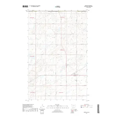
2017 Map of Fortuna
USGS Topo · Published 2017About this map
Fortuna sits at the intersection of ND 5 and 85, serving as a localized hub in the northwestern corner of North Dakota near the international border. The landscape is defined by the Jeffersonian grid of rural roads, including 144th Ave NW and 101st St NW, which segment the rolling prairie and numerous small wetlands characteristic of this high plains region. Genealogists and local historians can locate the Fortuna Cem south of the main settlement, a primary site for tracing family histories in Divide County. The map reveals the late-period infrastructure of the area, where section lines dictate the movement across the townships of t163n r101w and t164n r101w.
Find a feature on this map
27 named features on this map. Tap any name to fly to it.
Don’t see what you’re looking for? This feature index may not catch every label — zoom into the map to look around manually.
Map Details
Editions of this 2017 Fortuna Map
This is the sole edition of this map. No revisions or reprints were ever made.
Other maps of this area

1953 · Williston
USGS Topo · 1:250,000

1957 · Williston
USGS Topo · 1:250,000

1983 · Colgan West
USGS Topo · 1:24,000

1983 · Writing Rock North
USGS Topo · 1:24,000

1983 · Alkabo
USGS Topo · 1:24,000

1983 · Alexandria
USGS Topo · 1:24,000
1983 · Fortuna
USGS Topo · 1:24,000
1983 · Skjermo Lake
USGS Topo · 1:24,000

1984 · Crosby
USGS Topo · 1:100,000
2011 · Writing Rock North
USGS Topo · 1:24,000