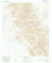
1965 Map of Fortuna Mine
USGS Topo · Published 1980About this map
The Fortuna Mine and Golden Dream Mine anchor this mid-1960s study of the Gila Mountains, a landscape defined by sharp elevation shifts and ephemeral water sources. The map captures the intersection of mining history and military presence, with a significant portion of the terrain designated as the Luke Air Force Range. Movement through this arid region follows historical paths such as the Camino Del Diablo and the Approximate West Route, which skirt the edges of the Yuma Desert. Infrastructure is sparse but critical, evidenced by the Water Tank and Tailings near the Fortuna workings. The drainage patterns of Fortuna Wash and landmarks like Red Top Mtn and Vapoki Ridge provide a clear view of the land as it appeared before modern desert development or conservation shifts.
Find a feature on this map
21 named features on this map. Tap any name to fly to it.
Don’t see what you’re looking for? This feature index may not catch every label — zoom into the map to look around manually.
Map Details
Editions of this 1965 Fortuna Mine Map
2 editions found
Other maps of this area

1926 · Fortuna
USGS Topo · 1:62,500

1926 · Wellton
USGS Topo · 1:62,500

1929 · Fortuna
USGS Topo · 1:62,500

1929 · Wellton
USGS Topo · 1:62,500

1942 · Yuma
USGS Topo · 1:250,000

1954 · El Centro
USGS Topo · 1:250,000

1955 · El Centro
USGS Topo · 1:250,000

1958 · El Centro
USGS Topo · 1:250,000

1961 · El Centro
USGS Topo · 1:250,000

1964 · El Centro
USGS Topo · 1:250,000