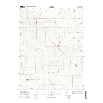
2015 Map of Fortuna
USGS Topo · Published 2015About this map
Fortuna and Aikinsville anchor this rural landscape along the border of Morgan and Moniteau Counties. This area is defined by a dense network of country roads such as Richland Creek Rd and Newkirk Cemetery Rd, which connect small crossroads settlements and family burial grounds. High ground at Reno Hill overlooks the headwaters of Little Richland Cr and Straight Fork, where the terrain transitions into the subtle valleys of the Missouri interior. Genealogists will find a concentrated cluster of historic burial sites, including Stone Cemetery, Allison Cemetery, and Liberty Cemetery. The southern portion of the sheet near Glensted shows the enduring agricultural character of the region, where roads like Barn Rd and Molasses Rd reflect the local economy and traditional land use patterns of the mid-2010s.
Find a feature on this map
74 named features on this map. Tap any name to fly to it.
Don’t see what you’re looking for? This feature index may not catch every label — zoom into the map to look around manually.
Map Details
Editions of this 2015 Fortuna Map
This is the sole edition of this map. No revisions or reprints were ever made.
Other maps of this area

1888 · Versailles
USGS Topo · 1:125,000

1888 · Boonville
USGS Topo · 1:125,000

1893 · Versailles
USGS Topo · 1:125,000

1904 · Eldon
USGS Topo · 1:62,500

1904 · Gravois Mills
USGS Topo · 1:62,500

1947 · Jefferson City
USGS Topo · 1:250,000

1949 · Gravois Mills
USGS Topo · 1:62,500

1951 · Latham
USGS Topo · 1:24,000

1952 · Tipton
USGS Topo · 1:24,000
1952 · Clarksburg
USGS Topo · 1:24,000