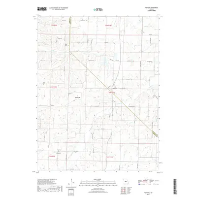
2017 Map of Fortuna
USGS Topo · Published 2017About this map
Fortuna and Aikinsville anchor this section of the Missouri landscape where the border of Moniteau and Morgan counties weaves through the hills. The terrain is defined by a dense network of local drainages, including Little Richland Cr, Straight Fork, and Willow Br, which have shaped the agricultural layout of the region. This 2017 survey reveals a persistent rural pattern of family-named roads and remote burial grounds that reflect the area's ancestral roots. Genealogists will find several distinct sites of interest, such as Glensted Cem near the settlement of Glensted and the Alkinsville Cem. Further north, Reno Hill stands near the confluence of Moon Valley Rd and Morrison Rd, illustrating how early topographic landmarks continue to dictate the modern road network in this part of the state.
Find a feature on this map
70 named features on this map. Tap any name to fly to it.
Don’t see what you’re looking for? This feature index may not catch every label — zoom into the map to look around manually.
Map Details
Editions of this 2017 Fortuna Map
This is the sole edition of this map. No revisions or reprints were ever made.
Other maps of this area

1888 · Versailles
USGS Topo · 1:125,000

1888 · Boonville
USGS Topo · 1:125,000

1893 · Versailles
USGS Topo · 1:125,000

1904 · Eldon
USGS Topo · 1:62,500

1904 · Gravois Mills
USGS Topo · 1:62,500

1947 · Jefferson City
USGS Topo · 1:250,000

1949 · Gravois Mills
USGS Topo · 1:62,500

1951 · Latham
USGS Topo · 1:24,000

1952 · Tipton
USGS Topo · 1:24,000
1952 · Clarksburg
USGS Topo · 1:24,000