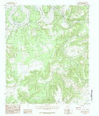
1984 Map of Fortune Bend
USGS Topo · Published 1984About this map
The Morris Sheppard Dam anchors this mid-1980s landscape, holding back the massive expanse of Possum Kingdom Lake as it winds through the Palo Pinto hills. The map highlights the serpentine path of the Brazos River south of the dam, where it carves deep, dramatic loops known as Fortune Bend and Flint Bend. This area represents a rugged intersection of hydraulic engineering and natural topography, with dramatic landmarks like Hells Gate marking the entrance to southern lake coves.
Find a feature on this map
23 named features on this map. Tap any name to fly to it.
Don’t see what you’re looking for? This feature index may not catch every label — zoom into the map to look around manually.
Map Details
Editions of this 1984 Fortune Bend Map
2 editions found
Other maps of this area

1890 · Breckenridge
USGS Topo · 1:125,000

1891 · Palo Pinto
USGS Topo · 1:125,000

1918 · Palo Pinto
USGS Topo · 1:125,000

1924 · Breckenridge 1-a
USGS Topo · 1:48,000

1924 · Palo Pinto 2-b
USGS Topo · 1:48,000

1924 · Palo Pinto 2-a
USGS Topo · 1:48,000

1924 · Palo Pinto 2-c
USGS Topo · 1:48,000

1924 · Breckenridge 1-d
USGS Topo · 1:48,000

1927 · Pickwick
USGS Topo · 1:62,500

1931 · Ivan
USGS Topo · 1:62,500