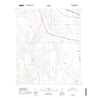
2020 Map of Fortune Fork
USGS Topo · Published 2020About this map
Roundaway Bayou and Brushy Bayou dominate this Madison Parish landscape, winding through an intricate network of wetlands and agricultural tracts. The terrain is defined by the legacy of river movement, seen in the curved lot lines and the Roundaway Bayou Vidal Cutoff at the southern edge. The small settlement of Fortune Fork sits in the northeast, near the Mount Cella Cem, while the Montrose Cem lies further south along the bayou banks. This 2020 survey illustrates the modern rural infrastructure of the region, including the Red Beard Dusting Service Airport, which supports the local agricultural economy. Genealogists and historians will find interest in the road network, from the historic alignment of Old US Hwy 65 to local routes like Barnes Crossing Rd and Sevier-Watts Rd, which trace the boundaries of long-established land holdings near Alligator Lake.
Find a feature on this map
27 named features on this map. Tap any name to fly to it.
Don’t see what you’re looking for? This feature index may not catch every label — zoom into the map to look around manually.
Map Details
Editions of this 2020 Fortune Fork Map
This is the sole edition of this map. No revisions or reprints were ever made.
Other maps of this area

1909 · Millikens Bend
USGS Topo · 1:24,000

1909 · Tallulah
USGS Topo · 1:24,000

1909 · Mound
USGS Topo · 1:24,000

1910 · Mound
USGS Topo · 1:31,680

1935 · Waverly
USGS Topo · 1:62,500

1935 · Shackleford Lake
USGS Topo · 1:62,500

1939 · Talla Bena
USGS Topo · 1:62,500

1955 · Jackson
USGS Topo · 1:250,000

1958 · Shackleford Lake
USGS Topo · 1:62,500

1961 · Jackson
USGS Topo · 1:250,000