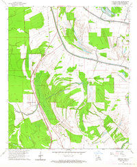
1963 Map of Fortune Fork
USGS Topo · Published 1964About this map
Fortune Fork serves as a focal point for this Madison Parish landscape in the early 1960s, where the winding courses of Brushy Bayou and Coon Bayou dictate the layout of local agriculture and transport. The Missouri Pacific railroad cuts a straight north-south line through the alluvial plain, contrasting with the ancient oxbow curves of Lake Sixteen and Horseshoe Lake.
Find a feature on this map
20 named features on this map. Tap any name to fly to it.
Don’t see what you’re looking for? This feature index may not catch every label — zoom into the map to look around manually.
Map Details
Editions of this 1963 Fortune Fork Map
This is the sole edition of this map. No revisions or reprints were ever made.
Other maps of this area

1909 · Millikens Bend
USGS Topo · 1:24,000

1909 · Tallulah
USGS Topo · 1:24,000

1909 · Mound
USGS Topo · 1:24,000

1910 · Mound
USGS Topo · 1:31,680

1935 · Waverly
USGS Topo · 1:62,500

1935 · Shackleford Lake
USGS Topo · 1:62,500

1939 · Talla Bena
USGS Topo · 1:62,500

1955 · Jackson
USGS Topo · 1:250,000

1958 · Shackleford Lake
USGS Topo · 1:62,500

1961 · Jackson
USGS Topo · 1:250,000