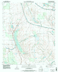
1994 Map of Fortune Fork
USGS Topo · Published 1997About this map
Roundaway Bayou and Walnut Bayou dominate this landscape in eastern Madison Parish, where the complex hydrology of the Mississippi River floodplain is visible in the oxbows and cutoffs. The small settlement of Fortune Fork sits at a crossroads near the confluence of several water bodies, serving as a focal point for the surrounding agricultural tracts. The map records several markers of early human occupation and burial, including an Indian Mound and the Mt Cella Cem and Montrose Cem.
Find a feature on this map
16 named features on this map. Tap any name to fly to it.
Don’t see what you’re looking for? This feature index may not catch every label — zoom into the map to look around manually.
Map Details
Editions of this 1994 Fortune Fork Map
This is the sole edition of this map. No revisions or reprints were ever made.
Other maps of this area

1909 · Millikens Bend
USGS Topo · 1:24,000

1909 · Tallulah
USGS Topo · 1:24,000

1909 · Mound
USGS Topo · 1:24,000

1910 · Mound
USGS Topo · 1:31,680

1935 · Waverly
USGS Topo · 1:62,500

1935 · Shackleford Lake
USGS Topo · 1:62,500

1939 · Talla Bena
USGS Topo · 1:62,500

1955 · Jackson
USGS Topo · 1:250,000

1958 · Shackleford Lake
USGS Topo · 1:62,500

1961 · Jackson
USGS Topo · 1:250,000