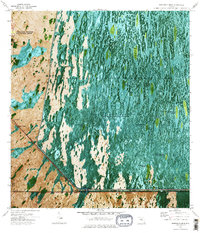
1973 Map of Fortymile Bend
USGS Topo · Published 1984About this map
Shark River Slough dominates this 1973 orthophotomap, where the watery expanse of the Everglades is interspersed with tree islands and cultural sites of the Miccosukee Indian Reservation. The landscape reveals a complex network of traditional camps and homesteads, including Smallpox Tommies Seminole Village, Pete Osceolas Farm, and Tommy Tigers Camp. This intersection of indigenous settlement and modern infrastructure is marked by the Tamiami Trail and the massive Dade-Collier Transition and Training Airport in the northwest. The aerial perspective highlights the unique geography of Miccosukee Tribe Island and the Airboat Trail system. Significant local landmarks such as the Miccosukee Sch and the Old Burying Ground reflect the deeply rooted heritage of the people living within the Everglades Wildlife Management Area.
Find a feature on this map
33 named features on this map. Tap any name to fly to it.
Don’t see what you’re looking for? This feature index may not catch every label — zoom into the map to look around manually.
Map Details
Editions of this 1973 Fortymile Bend Map
3 editions found
Other maps of this area

1956 · Miami
USGS Topo · 1:250,000

1958 · Miami
USGS Topo · 1:250,000

1972 · Shark Valley Lookout Tower
USGS Topo · 1:24,000

1972 · Lostmans Trail
USGS Topo · 1:24,000

1972 · Chekika Island
USGS Topo · 1:24,000

1973 · Fortymile Bend
USGS Topo · 1:24,000

1973 · Custard Apple Hammock
USGS Topo · 1:24,000

1973 · Fiftymile Bend
USGS Topo · 1:24,000

1973 · North Of Fiftymile Bend
USGS Topo · 1:24,000

1973 · Long Island
USGS Topo · 1:24,000
Featured Places
- Miccosukee Indian Village, FL
- Tommy Tigers Camp, FL
- Smallpox Tommies Old Place, FL
- Fortymile Bend, FL
- Jimmie Tigers Farm, FL