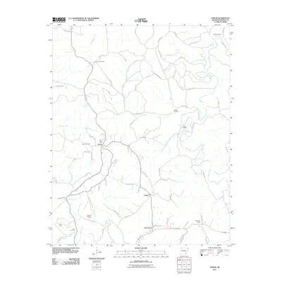
2011 Map of Forum
USGS Topo · Published 2011About this map
The community of Forum serves as a central hub for this Madison County landscape, where the Forum Post Office and Forum Lookout Tower stand near the intersection of several local routes. The settlement pattern reveals the distinct locations of Alabam and Old Alabam, offering a clear look at how this community transitioned over time. The eastern portion of the map is dominated by the winding path of the Kings River, while the southwest includes the northern reaches of Withrow Springs State Park along War Eagle Creek. Numerous family burial sites, such as Marshall Cemetery, McClain Cemetery, and Fritts Cemetery, are scattered across the hills and hollows, providing valuable markers for genealogists tracing local lineage. The terrain is further defined by several named landmarks including Jelico Hollow and Postoak Gap.
Find a feature on this map
38 named features on this map. Tap any name to fly to it.
Don’t see what you’re looking for? This feature index may not catch every label — zoom into the map to look around manually.
Map Details
Editions of this 2011 Forum Map
This is the sole edition of this map. No revisions or reprints were ever made.
Other maps of this area

1900 · Eureka Springs
USGS Topo · 1:125,000

1901 · Eureka Springs
USGS Topo · 1:125,000

1945 · Harrison
USGS Topo · 1:250,000

1949 · Harrison
USGS Topo · 1:250,000

1954 · Harrison
USGS Topo · 1:250,000

1957 · Mundell
USGS Topo · 1:24,000

1958 · Hindsville
USGS Topo · 1:24,000

1958 · Harrison
USGS Topo · 1:250,000

1964 · Harrison
USGS Topo · 1:250,000
1972 · Rockhouse
USGS Topo · 1:24,000