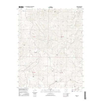
2017 Map of Forum
USGS Topo · Published 2017About this map
Forum and Alabam anchor this northern Arkansas landscape, where the winding Kings River and War Eagle Creek carve deep valleys into the Ozark terrain. The settlement pattern follows the contours of the land, with Old Alabam situated near the headwaters of Beaver Br. Family history is preserved across several small burial grounds, including the Marshall Cem near Forum and the Fritts Cem to the southwest. The presence of numerous Wildlife Management Areas, such as Wma 10, signifies the transition of former homesteads into protected natural corridors. Notable elevation shifts are marked by features like Diera Mtn and Postoak Gap, while the drainage network is defined by named hollows like Bear Hollow and Jelico Hollow, which dictate the paths of the local county road system.
Find a feature on this map
89 named features on this map. Tap any name to fly to it.
Don’t see what you’re looking for? This feature index may not catch every label — zoom into the map to look around manually.
Map Details
Editions of this 2017 Forum Map
This is the sole edition of this map. No revisions or reprints were ever made.
Other maps of this area

1900 · Eureka Springs
USGS Topo · 1:125,000

1901 · Eureka Springs
USGS Topo · 1:125,000

1945 · Harrison
USGS Topo · 1:250,000

1949 · Harrison
USGS Topo · 1:250,000

1954 · Harrison
USGS Topo · 1:250,000

1957 · Mundell
USGS Topo · 1:24,000

1958 · Hindsville
USGS Topo · 1:24,000

1958 · Harrison
USGS Topo · 1:250,000

1964 · Harrison
USGS Topo · 1:250,000
1972 · Rockhouse
USGS Topo · 1:24,000