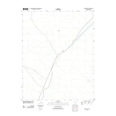
2012 Map of Fossil Peak
USGS Topo · Published 2012About this map
Fossil Peak stands as the primary landmark in this desert landscape of eastern Nevada, presiding over a terrain defined by sparse water sources and narrow passages. The White River threads through the eastern portion of the quadrangle, feeding into the John Wright Reservoir and passing through the geological constriction of the Hiko Narrows. This corridor serves as a vital artery for local transit, where modern routes parallel the river's course. Toward the west, the landscape transitions into more arid stretches, marked by isolated features like Bird Spring and the tracking of Mail Summit Rd as it cuts across the high basins. The map illustrates a region where life and travel are strictly dictated by the available gaps in the mountain topography and the rare presence of surface water.
Find a feature on this map
6 named features on this map. Tap any name to fly to it.
Don’t see what you’re looking for? This feature index may not catch every label — zoom into the map to look around manually.
Map Details
Editions of this 2012 Fossil Peak Map
This is the sole edition of this map. No revisions or reprints were ever made.
Other maps of this area

1954 · Caliente
USGS Topo · 1:250,000

1959 · Caliente
USGS Topo · 1:250,000

1970 · Hiko NE
USGS Topo · 1:24,000

1970 · Hiko SE
USGS Topo · 1:24,000

1970 · Seaman Wash
USGS Topo · 1:24,000

1970 · Fossil Peak
USGS Topo · 1:24,000
1970 · White River Narrows
USGS Topo · 1:24,000

1970 · Hiko
USGS Topo · 1:24,000

1985 · Mail Summit
USGS Topo · 1:24,000
1985 · Mount Irish SE
USGS Topo · 1:24,000