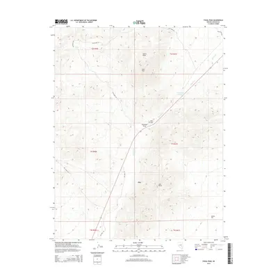
2014 Map of Fossil Peak
USGS Topo · Published 2014About this map
Pahranagat Valley serves as a critical corridor through this arid landscape, where the White River threads between the towering heights of the Seaman Range and the Hiko Range. The settlement of Hiko is situated along this route, historically significant as a watering point and ranching hub in an otherwise high-desert environment. This 2014 survey illustrates the region's dependence on scarce water sources, evidenced by Bird Spring and the John Wright Reservoir. To the west, the topography rises sharply toward Fossil Peak, while the southeastern corner levels out into the expanse of Sixmile Flat. The map also details a network of rural routes, including Mail Summit Rd and Dry Farm Rd, which reflect the long-standing agricultural and transit history of the basin. The constriction at Hiko Narrows highlights the geological constraints that have dictated road placement and water flow through the valley for generations.
Find a feature on this map
21 named features on this map. Tap any name to fly to it.
Don’t see what you’re looking for? This feature index may not catch every label — zoom into the map to look around manually.
Map Details
Editions of this 2014 Fossil Peak Map
This is the sole edition of this map. No revisions or reprints were ever made.
Other maps of this area

1954 · Caliente
USGS Topo · 1:250,000

1959 · Caliente
USGS Topo · 1:250,000

1970 · Hiko NE
USGS Topo · 1:24,000

1970 · Hiko SE
USGS Topo · 1:24,000

1970 · Seaman Wash
USGS Topo · 1:24,000

1970 · Fossil Peak
USGS Topo · 1:24,000
1970 · White River Narrows
USGS Topo · 1:24,000

1970 · Hiko
USGS Topo · 1:24,000

1985 · Mail Summit
USGS Topo · 1:24,000
1985 · Mount Irish SE
USGS Topo · 1:24,000