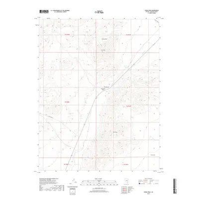
2018 Map of Fossil Peak
USGS Topo · Published 2018About this map
Fossil Peak stands as a prominent high point between the Seaman Range and the Hiko Range, defining the transition between high desert peaks and the drainage basins of southeastern Nevada. The White River threads through the center of the sheet, winding southward into the Hiko Narrows and across the Pahranagat Valley. This landscape reflects the sparse water resources of the Great Basin, where isolated features like Bird Spring and the John Wright Reservoir provided critical support for the region's ranching and travel history. A sense of the area's logistical past is preserved in the naming of Mail Summit Rd, which skirts the western hills. The broad, low-lying expanse of Sixmile Flat in the southeast corner contrasts with the surrounding mountains, illustrating the typical basin-and-range topography that dictated early settlement and transit routes through this part of Lincoln County.
Find a feature on this map
17 named features on this map. Tap any name to fly to it.
Don’t see what you’re looking for? This feature index may not catch every label — zoom into the map to look around manually.
Map Details
Editions of this 2018 Fossil Peak Map
This is the sole edition of this map. No revisions or reprints were ever made.
Other maps of this area

1954 · Caliente
USGS Topo · 1:250,000

1959 · Caliente
USGS Topo · 1:250,000

1970 · Hiko NE
USGS Topo · 1:24,000

1970 · Hiko SE
USGS Topo · 1:24,000

1970 · Seaman Wash
USGS Topo · 1:24,000

1970 · Fossil Peak
USGS Topo · 1:24,000
1970 · White River Narrows
USGS Topo · 1:24,000

1970 · Hiko
USGS Topo · 1:24,000

1985 · Mail Summit
USGS Topo · 1:24,000
1985 · Mount Irish SE
USGS Topo · 1:24,000