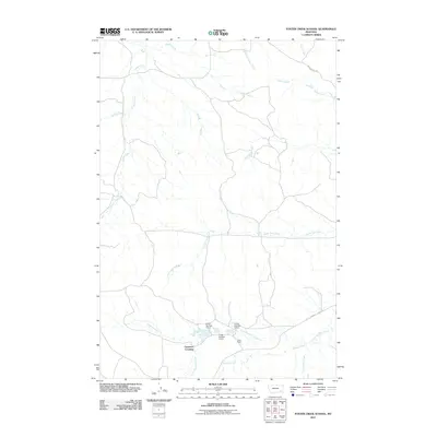
2011 Map of Foster Creek School
USGS Topo · Published 2011About this map
Cameron Crossing serves as a focal point in this portion of Powder River County, where the southern landscape is defined by the winding course of Little Pumpkin Creek. The map documents a specific agricultural and water-management footprint, most notably through the series of numbered structures on the Green Ranch property, including Green Number 4 Dam, Green Number 5 Dam, and Green Number 6 Dam.
Find a feature on this map
18 named features on this map. Tap any name to fly to it.
Don’t see what you’re looking for? This feature index may not catch every label — zoom into the map to look around manually.
Map Details
Editions of this 2011 Foster Creek School Map
This is the sole edition of this map. No revisions or reprints were ever made.
Other maps of this area

1954 · Ekalaka
USGS Topo · 1:250,000

1956 · Ekalaka
USGS Topo · 1:250,000

1958 · Ekalaka
USGS Topo · 1:250,000

1965 · Ekalaka
USGS Topo · 1:250,000

1966 · Stacey
USGS Topo · 1:24,000

1966 · Elk Ridge
USGS Topo · 1:24,000
1973 · Carey-Malone School
USGS Topo · 1:24,000
1973 · North Stacey School
USGS Topo · 1:24,000
1973 · Kirkpatrick Hill
USGS Topo · 1:24,000

1973 · Box Elder Creek
USGS Topo · 1:24,000