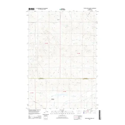
2014 Map of Foster Creek School
USGS Topo · Published 2014About this map
Cameron Crossing sits at the intersection of rural ranch roads and creek beds in this Montana landscape, where the Custer Co / Powder River Co line divides the terrain. The map details a high-plains environment defined by an intricate drainage system, including Little Pumpkin Cr, Horkan Cr, and Foster Cr. These watercourses dictate the placement of the sparse local infrastructure, such as the Foster Creek School, which serves as a central landmark in this remote ranching territory. Historically significant for its connection to local land use, the area is navigated via namesake paths like Foster Creek Rd and Horkan Creek Rd. The layout of section lines and township markers, including t1n r47e and t1s r48e, illustrates the enduring structure of the Public Land Survey System in this part of the American West.
Find a feature on this map
22 named features on this map. Tap any name to fly to it.
Don’t see what you’re looking for? This feature index may not catch every label — zoom into the map to look around manually.
Map Details
Editions of this 2014 Foster Creek School Map
This is the sole edition of this map. No revisions or reprints were ever made.
Other maps of this area

1954 · Ekalaka
USGS Topo · 1:250,000

1956 · Ekalaka
USGS Topo · 1:250,000

1958 · Ekalaka
USGS Topo · 1:250,000

1965 · Ekalaka
USGS Topo · 1:250,000

1966 · Stacey
USGS Topo · 1:24,000

1966 · Elk Ridge
USGS Topo · 1:24,000
1973 · Carey-Malone School
USGS Topo · 1:24,000
1973 · North Stacey School
USGS Topo · 1:24,000
1973 · Kirkpatrick Hill
USGS Topo · 1:24,000

1973 · Box Elder Creek
USGS Topo · 1:24,000