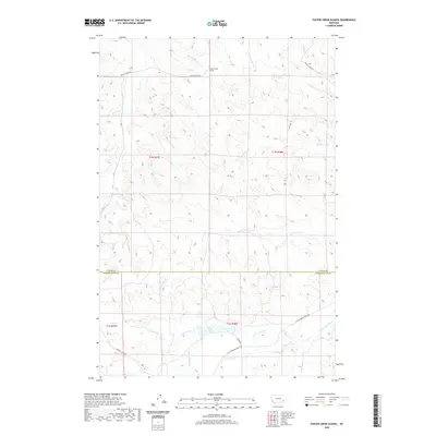
2020 Map of Foster Creek School
USGS Topo · Published 2020About this map
Foster Creek School serves as a central landmark in this high-plains landscape where the Custer Co Powder River Co boundary line bisects the territory. The map details a complex network of seasonal drainage and creek beds, including the Little Pumpkin Creek and Horkan Creek systems in the south. These watercourses have long dictated the placement of ranch roads and remote homesteads in this part of Montana. Travel across the terrain is traced through established routes like Foster Creek Rd and Horkan Creek Rd, which follow the natural contours of the land. The presence of numerous named branches, such as N Fork Foster Cr and Flat Butte Cr, illustrates the importance of water management and geography in the development of these rural townships.
Find a feature on this map
23 named features on this map. Tap any name to fly to it.
Don’t see what you’re looking for? This feature index may not catch every label — zoom into the map to look around manually.
Map Details
Editions of this 2020 Foster Creek School Map
This is the sole edition of this map. No revisions or reprints were ever made.
Other maps of this area

1954 · Ekalaka
USGS Topo · 1:250,000

1956 · Ekalaka
USGS Topo · 1:250,000

1958 · Ekalaka
USGS Topo · 1:250,000

1965 · Ekalaka
USGS Topo · 1:250,000

1966 · Stacey
USGS Topo · 1:24,000

1966 · Elk Ridge
USGS Topo · 1:24,000
1973 · Carey-Malone School
USGS Topo · 1:24,000
1973 · North Stacey School
USGS Topo · 1:24,000
1973 · Kirkpatrick Hill
USGS Topo · 1:24,000

1973 · Box Elder Creek
USGS Topo · 1:24,000