
1969 Map of Foster
USGS Topo · Published 1971About this map
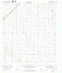
Atchison Topeka and Santa Fe railroad tracks cut across the northwestern corner of this West Texas landscape, connecting the small settlement of Lahey to the wider region. The terrain is characterized by numerous depressions and the winding course of Sulphur Springs Draw, which meanders through the southern half of the quadrangle. This 1969 survey captures an era of active land use in Terry County, where the agricultural presence is marked by a Cotton Gin and a prominent Water Tank. Scattered Oil Wells and a Gravel Pit indicate the local extractive industry, while the community of Foster and the nearby Foster Cem provide a focal point for genealogical research. The map's high-resolution topography reveals the subtle drainage patterns and land contours essential for understanding the historical development of this High Plains environment.
Find a feature on this map
11 named features on this map. Tap any name to fly to it.
Don’t see what you’re looking for? This feature index may not catch every label — zoom into the map to look around manually.
Map Details
Editions of this 1969 Foster Map
2 editions found
Other maps of this area

1954 · Hobbs
USGS Topo · 1:250,000

1954 · Brownfield
USGS Topo · 1:250,000

1958 · Brownfield
USGS Topo · 1:250,000

1958 · Hobbs
USGS Topo · 1:250,000

1962 · Brownfield
USGS Topo · 1:250,000

1969 · Brownfield East
USGS Topo · 1:24,000

1969 · Gomez
USGS Topo · 1:24,000

1969 · Loop
USGS Topo · 1:24,000

1969 · Ashmore
USGS Topo · 1:24,000
1969 · Union School
USGS Topo · 1:24,000