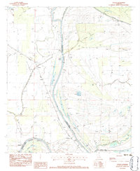
1983 Map of Foules
USGS Topo · Published 1984About this map
The Tensas River meanders through this portion of Louisiana, defining the border between Tensas and Catahoula Parishes. This landscape is a complex network of bayous and oxbow lakes, including Hoover Lake, Black Lake, and Mile Lake, which indicate the shifting hydrology of the Mississippi River floodplain. The small settlement of Foules sits near the Missouri Pacific railroad line, serving as a focal point for the surrounding agricultural community. Genealogy researchers will find several well-identified landmarks, such as Elder Shade Cem, Loam Land Cem, and New Zion Ch. A prominent Levee and a Double Wooden Pole Trans Line track through the basin, while the Little Tensas River joins the main branch in the south, illustrating the drainage patterns that shaped local development near Maitland.
Find a feature on this map
43 named features on this map. Tap any name to fly to it.
Don’t see what you’re looking for? This feature index may not catch every label — zoom into the map to look around manually.
Map Details
Editions of this 1983 Foules Map
This is the sole edition of this map. No revisions or reprints were ever made.
Other maps of this area

1921 · Natchez
USGS Topo · 1:48,000

1922 · Natchez
USGS Topo · 1:62,500

1939 · Red Gum
USGS Topo · 1:62,500

1939 · Natchez
USGS Topo · 1:62,500

1939 · Locust Ridge
USGS Topo · 1:62,500

1941 · Sicily Island
USGS Topo · 1:62,500

1953 · Natchez
USGS Topo · 1:250,000

1956 · Natchez
USGS Topo · 1:250,000

1957 · Sicily Island
USGS Topo · 1:62,500

1959 · Natchez
USGS Topo · 1:250,000