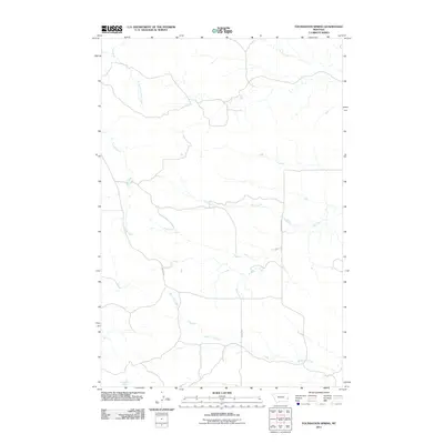
2011 Map of Foundation Spring
USGS Topo · Published 2011About this map
Foundation Spring serves as a central landmark in this high-plains landscape of eastern Montana, where water sources dictate the layout of travel and ranching infrastructure. The terrain is defined by a dendritic network of drainages, most notably Miles City Creek and Locate Creek, which carve winding paths through the territory. These watercourses, along with North Fork Locate Creek and Hay Creek, provide the primary topographical relief in an area primarily used for rangeland. Human activity is evidenced by a sparse but deliberate road network, specifically Mispah Rd and Foundation Rd, which facilitate movement between these isolated water points and the broader region. The proximity of Spring Creek in the northeast further emphasizes the critical importance of these specific named springs and creeks for livestock and land management in Fallon County.
Find a feature on this map
8 named features on this map. Tap any name to fly to it.
Don’t see what you’re looking for? This feature index may not catch every label — zoom into the map to look around manually.
Map Details
Editions of this 2011 Foundation Spring Map
This is the sole edition of this map. No revisions or reprints were ever made.
Other maps of this area

1953 · Miles City
USGS Topo · 1:250,000

1957 · Miles City
USGS Topo · 1:250,000

1958 · Miles City
USGS Topo · 1:250,000

1969 · Knowlton
USGS Topo · 1:24,000

1969 · Tepee Butte NE
USGS Topo · 1:24,000

1969 · Montague Butte
USGS Topo · 1:24,000
1980 · Miles City
USGS Topo · 1:100,000

1981 · Baker
USGS Topo · 1:100,000
1981 · Bracket Butte
USGS Topo · 1:24,000

1981 · Nelson Butte
USGS Topo · 1:24,000