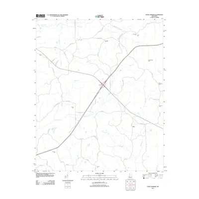
2012 Map of Four Corners
USGS Topo · Published 2012About this map
The crossroads community of Four Corners anchors this rural central Mississippi landscape, where a network of county roads like Pope Mill Rd and Guyton-Vowell Rd connects timberlands and small family settlements. This 2012 survey illustrates the enduring rural character of Winston County, centered around the village of Vowell and the community of Alice. The topography is defined by the winding paths of Lobutcha Cr and Bibalucta Cr, which drain the low rises of the Smallwood Hills. For those tracing local history or family roots, the map provides precise locations for several small burial grounds, including Ebenezer Cem in the southwest and Rattletrap Cem to the east. A notable landmark of the local timber economy and fire watch history, the Mars Hill Lookout Tower, stands prominently on the eastern edge of the quadrangle.
Find a feature on this map
71 named features on this map. Tap any name to fly to it.
Don’t see what you’re looking for? This feature index may not catch every label — zoom into the map to look around manually.
Map Details
Editions of this 2012 Four Corners Map
This is the sole edition of this map. No revisions or reprints were ever made.
Other maps of this area

1953 · Meridian
USGS Topo · 1:250,000

1953 · West Point
USGS Topo · 1:250,000

1957 · Meridian
USGS Topo · 1:250,000

1958 · West Point
USGS Topo · 1:250,000

1962 · Edinburg
USGS Topo · 1:62,500

1963 · West Point
USGS Topo · 1:250,000

1965 · Meridian
USGS Topo · 1:250,000

1972 · Pearl River
USGS Topo · 1:24,000

1972 · Plattsburg
USGS Topo · 1:24,000
1972 · Ethel SE
USGS Topo · 1:24,000