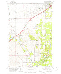
1973 Map of Four Lakes
USGS Topo · Published 1975About this map
Spokane International Airport and the sprawling Fairchild Air Force Base anchor the northern landscape of this 1970s survey, illustrating the Cold War-era aviation footprint on the outskirts of Spokane. The terrain is characterized by a series of prominent rises including Needham Hill and Wrights Hill, situated between the northern industrial transportation hubs and the educational center at Cheney to the south.
Find a feature on this map
46 named features on this map. Tap any name to fly to it.
Don’t see what you’re looking for? This feature index may not catch every label — zoom into the map to look around manually.
Map Details
Editions of this 1973 Four Lakes Map
2 editions found
Other maps of this area

1901 · Spokane
USGS Topo · 1:125,000

1903 · Oakesdale
USGS Topo · 1:125,000

1905 · Oakesdale
USGS Topo · 1:125,000

1943 · Medical Lake
USGS Topo · 1:62,500

1950 · Spokane SW
USGS Topo · 1:24,000

1950 · Spokane NW
USGS Topo · 1:24,000

1950 · Spokane
USGS Topo · 1:62,500

1954 · Airway Heights
USGS Topo · 1:24,000

1954 · Medical Lake
USGS Topo · 1:24,000

1954 · Medical Lake
USGS Topo · 1:62,500