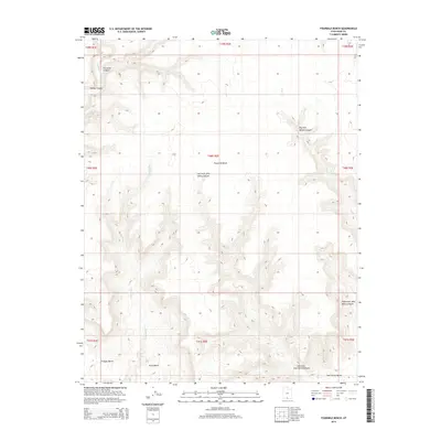
2014 Map of Fourmile Bench
USGS Topo · Published 2014About this map
The vast elevated plateau of Fourmile Bench dominates this southern Utah landscape, where deeply incised drainages carve through the high desert terrain. The drainage patterns of Smith Run and Tommy Smith Cr illustrate the complex erosion characteristic of this region, feeding into a network of canyons including Fourmile Canyon and Tommy Canyon in the northwest. To the south, a series of distinct geological flats emerge, including Snow Bench, Sit Down Bench, and the prominent John Henry Bench. These features highlight the isolated and topographical character of the land, defined by significant elevation changes between the benches and the canyon floors below. The eastern portion of the map is marked by the rugged descent into Dry Fork Wesses Canyon and the headwaters of the Left Fork and Right Fork of John Henry Canyon, showing the intricate natural boundaries that shaped early transit and land use in this part of Kane County.
Find a feature on this map
21 named features on this map. Tap any name to fly to it.
Don’t see what you’re looking for? This feature index may not catch every label — zoom into the map to look around manually.
Map Details
Editions of this 2014 Fourmile Bench Map
This is the sole edition of this map. No revisions or reprints were ever made.
Other maps of this area

1886 · Escalante
USGS Topo · 1:250,000

1922 · Upper Last Chance
USGS Topo · 1:63,360

1953 · Nipple Butte
USGS Topo · 1:62,500

1954 · Paria
USGS Topo · 1:62,500

1956 · Escalante
USGS Topo · 1:250,000

1960 · Escalante
USGS Topo · 1:250,000

1964 · Horse Flat
USGS Topo · 1:24,000
1964 · Butler Valley
USGS Topo · 1:24,000

1968 · Fourmile Bench
USGS Topo · 1:24,000
1968 · Petes Cove
USGS Topo · 1:24,000