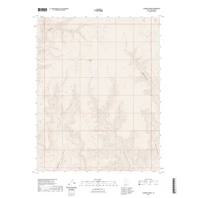
2023 Map of Fourmile Bench
USGS Topo · Published 2023About this map
Fourmile Bench rises above a complex drainage system in this high-desert portion of Kane County, where seasonal watercourses like Tommy Smith Creek and Smith Run have carved deep into the landscape. The geography is defined by a series of branching canyon systems, including the notable Left Fork John Henry Canyon and Right Fork John Henry Canyon which dominate the southern reach. The intricate contour lines show the sharp transition from the flat top of the bench down into narrow corridors such as Tommy Canyon and Fourmile Canyon. This 2023 survey illustrates the dramatic geological relief of the region, where dry watercourses like Dry Fork Wesses Canyon and Pet Hollow reveal the long-term erosion patterns of the Colorado Plateau.
Find a feature on this map
11 named features on this map. Tap any name to fly to it.
Don’t see what you’re looking for? This feature index may not catch every label — zoom into the map to look around manually.
Map Details
Editions of this 2023 Fourmile Bench Map
This is the sole edition of this map. No revisions or reprints were ever made.
Other maps of this area

1886 · Escalante
USGS Topo · 1:250,000

1922 · Upper Last Chance
USGS Topo · 1:63,360

1953 · Nipple Butte
USGS Topo · 1:62,500

1954 · Paria
USGS Topo · 1:62,500

1956 · Escalante
USGS Topo · 1:250,000

1960 · Escalante
USGS Topo · 1:250,000

1964 · Horse Flat
USGS Topo · 1:24,000
1964 · Butler Valley
USGS Topo · 1:24,000

1968 · Fourmile Bench
USGS Topo · 1:24,000
1968 · Petes Cove
USGS Topo · 1:24,000