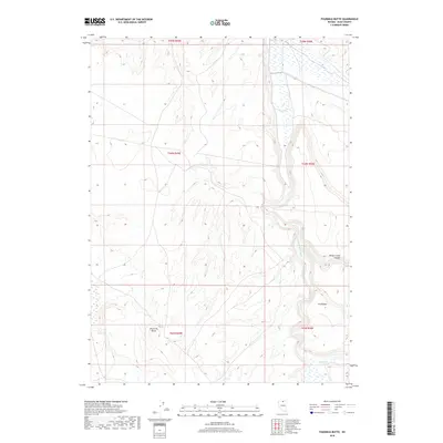
2018 Map of Fourmile Butte
USGS Topo · Published 2018About this map
Fourmile Butte anchors the southwestern landscape of this Elko County region, a terrain defined by the winding course of the S Fork Owyhee River. This high-desert drainage system reveals a complex network of canyons and pockets, including the prominent Wilson Creek Canyon and the curiously named V N Pocket to the east. The river is joined from the southeast by Deep Cr, cutting through a landscape primarily organized by township and range lines. The sparse distribution of named features underscores the remote character of this part of Nevada, where natural landmarks and water sources dictated movement and land use. For those studying the geography of the Owyhee watershed, the map provides precise data on the elevation and drainage patterns that characterize this high-elevation basin.
Find a feature on this map
11 named features on this map. Tap any name to fly to it.
Don’t see what you’re looking for? This feature index may not catch every label — zoom into the map to look around manually.
Map Details
Editions of this 2018 Fourmile Butte Map
This is the sole edition of this map. No revisions or reprints were ever made.
Other maps of this area

1955 · McDermitt
USGS Topo · 1:250,000

1959 · McDermitt
USGS Topo · 1:250,000

1964 · Hat Peak
USGS Topo · 1:62,500

1964 · Wilson Reservoir
USGS Topo · 1:62,500
1974 · Twelvemile Flat SE
USGS Topo · 1:24,000

1974 · Middle Draw Reservoir
USGS Topo · 1:24,000

1974 · Desert Ranch
USGS Topo · 1:24,000

1982 · Bull Run Mts
USGS Topo · 1:100,000
1987 · Fourmile Butte
USGS Topo · 1:24,000
1987 · Cornucopia Ridge
USGS Topo · 1:24,000