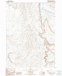
1987 Map of Fourmile Butte
USGS Topo · Published 1987About this map
The South Fork Owyhee River snakes through the high-desert landscape of Elko County, forming a deep, winding channel that anchors this 1987 survey. Located in the northern reaches of the state, the area is defined by the broad drainage systems of Bull Run and Deep Creek which feed into the main river corridor. Human presence in this isolated terrain is centered on the YP Ranch, located near the northern edge of the sheet. The map documents the network of primitive 4wd tracks that provide the only access across the high ground between the river and Fourmile Butte. This area serves as a primary example of Nevada's ranching and open-range country during the late 20th century, where the geology of Wilson Creek Canyon and the surrounding drainages dictated the placement of early roads and water-access points.
Find a feature on this map
11 named features on this map. Tap any name to fly to it.
Don’t see what you’re looking for? This feature index may not catch every label — zoom into the map to look around manually.
Map Details
Editions of this 1987 Fourmile Butte Map
This is the sole edition of this map. No revisions or reprints were ever made.
Other maps of this area

1955 · McDermitt
USGS Topo · 1:250,000

1959 · McDermitt
USGS Topo · 1:250,000

1964 · Hat Peak
USGS Topo · 1:62,500

1964 · Wilson Reservoir
USGS Topo · 1:62,500
1974 · Twelvemile Flat SE
USGS Topo · 1:24,000

1974 · Middle Draw Reservoir
USGS Topo · 1:24,000

1974 · Desert Ranch
USGS Topo · 1:24,000

1982 · Bull Run Mts
USGS Topo · 1:100,000
1987 · Cornucopia Ridge
USGS Topo · 1:24,000
1987 · I L Ranch
USGS Topo · 1:24,000