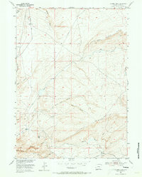
1953 Map of Fourmile Ridge
USGS Topo · Published 1973About this map
Irene Ranch sits at the base of the drainage network in this high-altitude livestock landscape of Carbon County. The topography is defined by the prominent Fourmile Ridge and the broad Shirley Basin to the south, where intermittent water sources like Alkali Creek and South Fork Sage Creek drain the arid terrain. The presence of Mine Hill suggests the early mineral exploration that often coincided with ranching in this part of Wyoming. The area's relative isolation is managed by the Kortes Road, which provides the primary north-south transit through a series of canyons including Wolf Canyon and North Wolf Canyon. Surveyors utilized high points like VABM 6862 Cherry to map this complex system of draws and rims, including the distinct Dry Creek Rim in the northeast corner of the quadrangle.
Find a feature on this map
24 named features on this map. Tap any name to fly to it.
Don’t see what you’re looking for? This feature index may not catch every label — zoom into the map to look around manually.
Map Details
Editions of this 1953 Fourmile Ridge Map
3 editions found
Other maps of this area

1951 · Bear Mountain
USGS Topo · 1:24,000

1951 · Bear Spring
USGS Topo · 1:24,000

1951 · Pathfinder Dam
USGS Topo · 1:24,000

1953 · Leo
USGS Topo · 1:24,000

1953 · Seminoe Dam NE
USGS Topo · 1:24,000

1953 · Fourmile Point
USGS Topo · 1:24,000

1953 · Fourmile Ridge
USGS Topo · 1:24,000

1953 · The Q Ranch
USGS Topo · 1:24,000

1953 · Beaver Creek
USGS Topo · 1:24,000

1955 · Casper
USGS Topo · 1:250,000