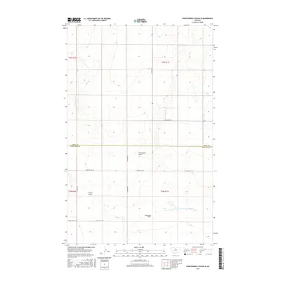
2017 Map of Fourteenmile Coulee SE
USGS Topo · Published 2017About this map
Hill Co Chouteau Co divides this rural Montana landscape, where the northern plains of the Big Sky State are defined by a series of significant drainage systems. The terrain is dominated by the southeastward flow of Fourteenmile Coulee, Twelvemile Coulee, and Sixmile Coulee, which carve distinct depressions across the high prairie. This 2017 survey reflects a modern agricultural and ranching layout, centered on a grid of gravel and section-line roads such as Gilford Rd S and N Lonesome Lake Rd. The road network, including family or place-named routes like Gardiner Rd N and Edwards Rd, provides the primary structure for land access between the county lines. Small depressions and seasonal wetlands are scattered across the higher ground between the coulees, illustrating the complex natural hydrology of this semi-arid region.
Find a feature on this map
16 named features on this map. Tap any name to fly to it.
Don’t see what you’re looking for? This feature index may not catch every label — zoom into the map to look around manually.
Map Details
Editions of this 2017 Fourteenmile Coulee SE Map
This is the sole edition of this map. No revisions or reprints were ever made.
Other maps of this area

1904 · Boxelder
USGS Topo · 1:62,500

1906 · Lonesome
USGS Topo · 1:62,500

1906 · Boxelder
USGS Topo · 1:62,500

1919 · Big Sandy
USGS Topo · 1:125,000

1954 · Shelby
USGS Topo · 1:250,000

1958 · Shelby
USGS Topo · 1:250,000

1969 · Box Elder NW
USGS Topo · 1:24,000

1969 · Fourteenmile Coulee SW
USGS Topo · 1:24,000
1969 · Lonesome Lake
USGS Topo · 1:24,000

1969 · Fourteenmile Coulee NW
USGS Topo · 1:24,000