
1906 Map of Lonesome
USGS Topo · Published 1906About this map
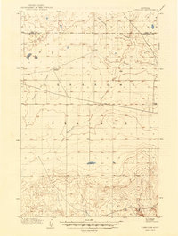
Lonesome Prairie dominates this 1904 survey, revealing a vast and sparsely settled expanse in Chouteau County at the start of the twentieth century. The map is defined by its deep, winding coulees that cut through the high plains, including Fourteenmile Coulee to the north and the extensive Twelvemile Coulee further south. These drainages, along with Sixmile Coulee and Dry Fork Coulee, illustrate the vital hydrological patterns that dictated early ranching and survival in north-central Montana.
Find a feature on this map
19 named features on this map. Tap any name to fly to it.
Don’t see what you’re looking for? This feature index may not catch every label — zoom into the map to look around manually.
Map Details
Editions of this 1906 Lonesome Map
2 editions found
Other maps of this area

1904 · Boxelder
USGS Topo · 1:62,500

1906 · Boxelder
USGS Topo · 1:62,500

1919 · Big Sandy
USGS Topo · 1:125,000

1953 · Boggs Island
USGS Topo · 1:24,000

1953 · Verona
USGS Topo · 1:24,000

1954 · Shelby
USGS Topo · 1:250,000

1958 · Shelby
USGS Topo · 1:250,000
1964 · Day School
USGS Topo · 1:24,000

1969 · Fourteenmile Coulee SW
USGS Topo · 1:24,000
1969 · Lonesome Lake
USGS Topo · 1:24,000