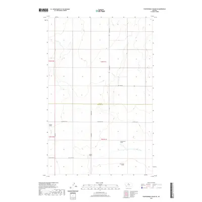
2020 Map of Fourteenmile Coulee SE
USGS Topo · Published 2020About this map
Deeply etched drainage patterns define this Montana landscape, where Sixmile Coulee and Fourteenmile Coulee carve through the high plains. The map records the boundary where Hill and Chouteau counties meet, a quiet agricultural divide structured by the Public Land Survey System. Travel in the region follows a sparse but deliberate grid of section-line roads, including Gilford Rd S and N Lonesome Lake Rd, which provide access to the wide-open ranching and dry-land farming territories. Water is the primary architect here; intermittent streams like Twelvemile Coulee illustrate the hydraulic connectivity of the Big Sandy creek drainage system. The settlement pattern is characterized by long-distance connectivity rather than concentrated towns, with routes like Box Elder Rd linking the isolated townships of T30N and T29N.
Find a feature on this map
16 named features on this map. Tap any name to fly to it.
Don’t see what you’re looking for? This feature index may not catch every label — zoom into the map to look around manually.
Map Details
Editions of this 2020 Fourteenmile Coulee SE Map
This is the sole edition of this map. No revisions or reprints were ever made.
Other maps of this area

1904 · Boxelder
USGS Topo · 1:62,500

1906 · Lonesome
USGS Topo · 1:62,500

1906 · Boxelder
USGS Topo · 1:62,500

1919 · Big Sandy
USGS Topo · 1:125,000

1954 · Shelby
USGS Topo · 1:250,000

1958 · Shelby
USGS Topo · 1:250,000

1969 · Box Elder NW
USGS Topo · 1:24,000

1969 · Fourteenmile Coulee SW
USGS Topo · 1:24,000
1969 · Lonesome Lake
USGS Topo · 1:24,000

1969 · Fourteenmile Coulee NW
USGS Topo · 1:24,000