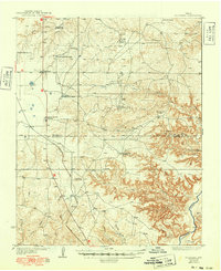
1936 Map of Fourways
USGS Topo · Published 1949About this map
The Panhandle and Santa Fe railroad corridor anchors this mid-1930s landscape, cutting a north-south path through the High Plains transition toward the Canadian River. The terrain shifts from the open rangeland of Moore County into the deeply dissected breaks of the Big Canyon area in Potter County. This period reveals a specialized ranching and industrial economy, where large family operations like the Masterson Ranch and Sneeds Ranch operated alongside modern infrastructure such as the Bivins Booster Station and the settlement at Exell. Numerous outposts, including Kilgore Sheep Camp and Sneeds South Camp, suggest a highly managed landscape of livestock production. Significant natural landmarks like John Ray Butte rise above the drainage networks of Blue Creek and North Plum Creek, which feed into the primary river valley at the bottom of the sheet.
Find a feature on this map
27 named features on this map. Tap any name to fly to it.
Don’t see what you’re looking for? This feature index may not catch every label — zoom into the map to look around manually.
Map Details
Editions of this 1936 Fourways Map
2 editions found
Other maps of this area

1934 · Ady
USGS Topo · 1:62,500

1934 · Cliffside
USGS Topo · 1:62,500

1936 · Fourways
USGS Topo · 1:62,500

1936 · Cliffside
USGS Topo · 1:62,500

1936 · Ady
USGS Topo · 1:62,500

1939 · Sanford
USGS Topo · 1:62,500

1953 · Chunky
USGS Topo · 1:24,000

1953 · Marsh
USGS Topo · 1:24,000

1953 · Puente
USGS Topo · 1:24,000

1953 · Alibates Ranch
USGS Topo · 1:24,000