
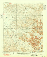
1936 Map of Fourways
USGS Topo · Published 1936About this map
The cattle ranching and early petroleum infrastructure of the Texas Panhandle define this landscape, surveyed shortly after the Great Depression. The map records a complex network of family holdings and livestock operations across the Moore and Potter County line, including the Masterson Ranch, Sneeds Ranch, and several divisions of the Thompson family lands such as the Thompson Headquarters Ranch and Thompson North Ranch. The presence of the Bivins Booster Station and the settlement of Exell highlights the region's developing energy sector. To the south, the terrain breaks sharply as the plains give way to the deep erosion of Big Canyon and Spring Creek, eventually reaching the wide bed of the Canadian River. Transportation is anchored by the Panhandle and Santa Fe railroad and the shared route of U.S. Highway 385 and State Highway 5.
Find a feature on this map
29 named features on this map. Tap any name to fly to it.
Don’t see what you’re looking for? This feature index may not catch every label — zoom into the map to look around manually.
Map Details
Editions of this 1936 Fourways Map
2 editions found
Other maps of this area

1934 · Ady
USGS Topo · 1:62,500

1934 · Cliffside
USGS Topo · 1:62,500

1936 · Cliffside
USGS Topo · 1:62,500

1936 · Ady
USGS Topo · 1:62,500

1939 · Sanford
USGS Topo · 1:62,500

1953 · Chunky
USGS Topo · 1:24,000

1953 · Marsh
USGS Topo · 1:24,000

1953 · Puente
USGS Topo · 1:24,000

1953 · Alibates Ranch
USGS Topo · 1:24,000

1953 · Evans Canyon
USGS Topo · 1:24,000