
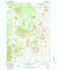
1981 Map of Fox Butte
USGS Topo · Published 1981About this map
Fox Butte and its Lookout Tower command the high ground in this section of the Deschutes National Forest along the border of Lake and Deschutes Counties. The 1981 terrain is defined by volcanic features, including the prominent Blowout and Lava flows to the south, interspersed with isolated high points like Burnt Butte and Squaw Mtn. Human presence in this arid landscape is marked by a network of water management features essential for survival and livestock, ranging from Kittredge Reservoir and West Reservoir to deeper sources such as Derrick Well and Cook Well. The scattered namesake flats, such as Watkins Flat and Aspen Flat, break up the volcanic ridges, while the small Glen Cabin sits as a lonely structure near the southern forest boundary. This map records the essential water infrastructure and forest service management points of the High Desert during the late twentieth century.
Find a feature on this map
33 named features on this map. Tap any name to fly to it.
Don’t see what you’re looking for? This feature index may not catch every label — zoom into the map to look around manually.
Map Details
Editions of this 1981 Fox Butte Map
2 editions found
Other maps of this area

1955 · Crescent
USGS Topo · 1:250,000

1957 · Crescent
USGS Topo · 1:250,000

1958 · Crescent
USGS Topo · 1:250,000

1970 · Crescent
USGS Topo · 1:250,000

1981 · Hogback Butte
USGS Topo · 1:24,000

1981 · Cougar Mtn
USGS Topo · 1:24,000
1981 · Plot Butte
USGS Topo · 1:24,000
1982 · Sixteen Butte
USGS Topo · 1:24,000
1982 · Firestone Butte
USGS Topo · 1:24,000

1982 · Jacks Place
USGS Topo · 1:24,000