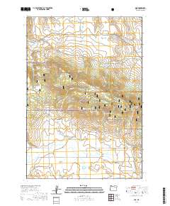
2020 Map of Fox
USGS Topo · Published 2020About this map
Fox Valley forms a significant topographic depression in the southern portion of this region, serving as a hub for local ranching and settlement. The small community of Fox sits at the intersection of several local routes, including Vaughn Rd and Corben Ln, where Smith Creek and Fox Creek converge. The landscape is dominated by the high ridgeline of Long Creek Mtn, reaching its height at Long Creek Mountain Summit. This mountainous spine is protected within the Malheur National Forest, which covers the central east-west belt of the terrain.
Find a feature on this map
36 named features on this map. Tap any name to fly to it.
Don’t see what you’re looking for? This feature index may not catch every label — zoom into the map to look around manually.
Map Details
Editions of this 2020 Fox Map
This is the sole edition of this map. No revisions or reprints were ever made.
Other maps of this area

1949 · Long Creek
USGS Topo · 1:62,500

1950 · Ritter
USGS Topo · 1:62,500

1951 · Long Creek
USGS Topo · 1:62,500

1951 · Courtrock
USGS Topo · 1:62,500

1951 · Monument
USGS Topo · 1:62,500

1952 · Ritter
USGS Topo · 1:62,500

1955 · Canyon City
USGS Topo · 1:250,000

1959 · Canyon City
USGS Topo · 1:250,000

1980 · Monument
USGS Topo · 1:100,000
1990 · Donaldson Creek
USGS Topo · 1:24,000