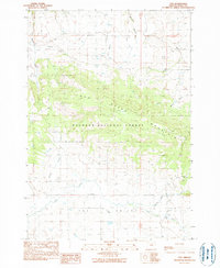
1990 Map of Fox
USGS Topo · Published 1990About this map
Fox Valley spreads across the southern portion of this 1990 provisional survey, revealing a landscape defined by timber, ranching, and mountain terrain. Much of the central and northern map is dominated by the Malheur National Forest, which encompasses the significant height of Long Creek Mountain. The industrial character of the valley floor is evidenced by the presence of the Fox Mill and Waterbury Mill, likely tied to the region's logging legacy.
Find a feature on this map
22 named features on this map. Tap any name to fly to it.
Don’t see what you’re looking for? This feature index may not catch every label — zoom into the map to look around manually.
Map Details
Editions of this 1990 Fox Map
This is the sole edition of this map. No revisions or reprints were ever made.
Other maps of this area

1949 · Long Creek
USGS Topo · 1:62,500

1950 · Ritter
USGS Topo · 1:62,500

1951 · Long Creek
USGS Topo · 1:62,500

1951 · Courtrock
USGS Topo · 1:62,500

1951 · Monument
USGS Topo · 1:62,500

1952 · Ritter
USGS Topo · 1:62,500

1955 · Canyon City
USGS Topo · 1:250,000

1959 · Canyon City
USGS Topo · 1:250,000

1980 · Monument
USGS Topo · 1:100,000
1990 · Donaldson Creek
USGS Topo · 1:24,000