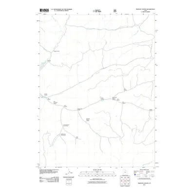
2011 Map of Francis Canyon
USGS Topo · Published 2011About this map
Lost Creek Reservoir serves as a primary hydrological anchor in this high-altitude landscape of northern Utah, where water management and wilderness recreation converge. The 2011 survey details a complex network of seasonal and perennial drainages, including Squaw Creek, Blue Fork Creek, and Saleratus Creek, which carve out a rugged series of named hollows. For genealogists and local historians, family-named landmarks like Doc Dorlands Hollow and Joe Hollow provide clues to early land use or homesteading. The presence of the Lost Creek Campground at the edge of the reservoir indicates the area's modern role in public land management under the U.S. Forest Service. The map traces the intricate branching of the Left Hand Fork Coal Hollow, Middle Fork Coal Hollow, and Right Hand Fork Coal Hollow, illustrating the topographic complexity that dictates travel through these mountain corridors.
Find a feature on this map
26 named features on this map. Tap any name to fly to it.
Don’t see what you’re looking for? This feature index may not catch every label — zoom into the map to look around manually.
Map Details
Editions of this 2011 Francis Canyon Map
This is the sole edition of this map. No revisions or reprints were ever made.
Other maps of this area

1954 · Ogden
USGS Topo · 1:250,000

1958 · Ogden
USGS Topo · 1:250,000

1960 · Ogden
USGS Topo · 1:250,000

1964 · Lost Creek Dam
USGS Topo · 1:24,000

1964 · Francis Canyon
USGS Topo · 1:24,000
1964 · Henefer
USGS Topo · 1:24,000
1964 · Heiners Creek
USGS Topo · 1:24,000

1968 · Horse Ridge
USGS Topo · 1:24,000

1968 · Shearing Corral
USGS Topo · 1:24,000

1968 · Mc Kay Hollow
USGS Topo · 1:24,000