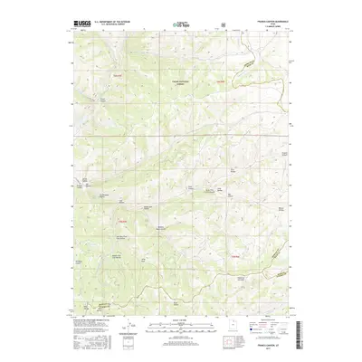
2017 Map of Francis Canyon
USGS Topo · Published 2017About this map
Cache National Forest dominates this northern Utah landscape, where a dense network of drainages and named hollows defines the transition across the borders of Morgan, Rich, and Summit Counties. The western edge of the sheet is anchored by the Lost Cr Reservoir, fed by Lost Cr and nearby Killfoil Creek. This is a landscape of rugged high-elevation terrain, where family-named and descriptive landmarks like Doc Dorlands Hollow, Beaver Dam Hollow, and Quaking Aspen Hollow indicate a history of local land use ranging from livestock grazing to early resource extraction. The southern reaches of the quadrangle contain distinctive geological and water features such as Yellowjacket Spring and the curiously named Hollow of the Holes, providing a clear record of the area's hydrology and topography before any major modern development altered these remote drainages.
Find a feature on this map
38 named features on this map. Tap any name to fly to it.
Don’t see what you’re looking for? This feature index may not catch every label — zoom into the map to look around manually.
Map Details
Editions of this 2017 Francis Canyon Map
This is the sole edition of this map. No revisions or reprints were ever made.
Other maps of this area

1954 · Ogden
USGS Topo · 1:250,000

1958 · Ogden
USGS Topo · 1:250,000

1960 · Ogden
USGS Topo · 1:250,000

1964 · Lost Creek Dam
USGS Topo · 1:24,000

1964 · Francis Canyon
USGS Topo · 1:24,000
1964 · Henefer
USGS Topo · 1:24,000
1964 · Heiners Creek
USGS Topo · 1:24,000

1968 · Horse Ridge
USGS Topo · 1:24,000

1968 · Shearing Corral
USGS Topo · 1:24,000

1968 · Mc Kay Hollow
USGS Topo · 1:24,000