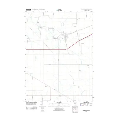
2012 Map of Franklin Grove
USGS Topo · Published 2012About this map
Franklin Cr meanders through the heart of this Lee County landscape, defining the rural character of the region as it appeared in the early 21st century. The map centers on the community of Franklin Grove, highlighting local landmarks like Sundays Bridge and Mondays Bridge crossing the creek north of town. This survey serves as a precise record of the agricultural footprint in Northern Illinois, documenting longstanding family sites such as Heng Farm and Hart Farms. For those researching local history or genealogy, the map identifies three distinct burial grounds: Emmert Cem to the west, Bradford Cem to the east, and Temperance Hill Cem in the southern portion of the quadrangle. Transport and infrastructure are represented by the local Po downtown and the nearby Gittleson Farms Airport, illustrating how traditional farming and modern aviation coexist in this prairie setting.
Find a feature on this map
46 named features on this map. Tap any name to fly to it.
Don’t see what you’re looking for? This feature index may not catch every label — zoom into the map to look around manually.
Map Details
Editions of this 2012 Franklin Grove Map
This is the sole edition of this map. No revisions or reprints were ever made.
Other maps of this area

1918 · Dixon
USGS Topo · 1:62,500

1950 · Dixon
USGS Topo · 1:62,500

1951 · Amboy
USGS Topo · 1:62,500

1952 · Rochelle
USGS Topo · 1:62,500

1952 · Mendota
USGS Topo · 1:62,500

1958 · Aurora
USGS Topo · 1:250,000

1961 · Aurora
USGS Topo · 1:250,000
1975 · Chana
USGS Topo · 1:24,000
1975 · Ashton
USGS Topo · 1:24,000
1982 · Sublette
USGS Topo · 1:24,000
Featured Places
- Franklin Grove, IL
- Ashton Township, IL
- Franklin Grove Township, IL
- Nachusa Township, IL
- Amboy Township, IL